One of the primary reasons that my hiking lags far behind last year’s totals is that at the end of the season I experienced a rather catastrophic equipment failure. My boots that were only two years old developed a hole in the toe. With the onset of winter, that represented a real catastrophe.
Fortunately, the boots were purchased at REI and they made good on their promise to take things back, exchanging the summer boots for a more winter boot. The only problem was that the winter boot was not going to be broken in unless I decided to do a lot of hiking in them, and additionally I wasn’t really that interested in trying to break them in since I had successfully transitioned to a more summer boot two years ago.
At any rate, since the only thing that I knew would work were tennis shoes, I had to avoid the mountain until all of the snow was gone, and by that time there were plenty of other interruptions and the climbing fell to the background. Today however marks climb number 8 for the season, and now I’m only 8 behind where I was last year. Since Saturday June 30 I’ve climbed the mountain 5 times for a total of 20,500 feet.
Today’s climb was uneventful, and although I might have added a couple of photos, I walked out of the house without the main card in the camera which left me with the ability to take only 8 photos.
I did improve my time by a whopping 5 minutes, so that means that if I want to break 3 hours there is a lot of work to do still. I suppose I’m going to have to get to the gym or get on the hill in the mornings so that I can build up my cardio even more, but that is hard to do when you travel as much as I do. Tuesday it’s off to Phoenix for the day and then I fly into Grand Junction, Colorado for another day’s meetings. I’m home for 4 days and then back on the airplane again for three days the following week.
The mountain did get hours of rain and the evidence was everywhere. My rain gauge from the post on July 4 was full again and there were obvious signs that the trails had been flooded just about everywhere. The great news is that the dust is gone from the trails but give it a couple of days without rain and it will be back.
I did stop and take another photo of the wildflower that I posted two days ago, just to show it in it’s larger setting. I figure that it might help for someone to identify it.
I am pretty confident that I’ve figured it out, Antelope Sage – by the common name.
One thing I noticed today was that when I said that the pink clusters were about the size of a dime, I was way off. It’s about the size of a third of a dime. These are really little flowers.
Today’s photo of the day in the photo blog is a close up of the Spreading Fleabane, a member of the Aster family. It’s a biennial or a short lived perennial that seems to favor the upper end of it’s elevation range here in the Sandias, because it is quite common at the 10,000 ft. level.
Note to self, check to see that the right card is in the camera before hiking.
I set my alarm last night for the ungodly hour of 5:30 am for a Saturday morning. Theoretically one could sleep in on a Saturday, but when you have this itch to climb the mountain in the monsoon season, then early it is.
The monsoon season pushes moisture up into New Mexico from the Gulf of Mexico and as air is pushed over the mountains it rises and we have the makings of a thunderstorm factory, right here in my back yard. I tried to take a shot of the storms building over the mountain yesterday, but the battery in my briefcase camera was dead. So I’m substituting an image from a couple of years ago that shows what happens around 10 to 11 every morning when there is a big flow of moisture.
After being caught a couple of times in serious lightning, hail and torrential downpours, I’ve decided that during monsoon season there is only one answer to this problem, and that is to finish early and get off of the mountain before the rain begins
Today’s forecast was for possible thunderstorms in the morning but the sky looked clear enough that I left my rain gear in my trunk. Once I pulled out my backpack I had to deal with a leaking water supply but fortunately none of the water got onto the camera and I set out on climb number four. Time on the trail: 6:45am. The big time challenge is in place for me but I always have to remember that my best time ever was achieved without taking one single photograph on the hike.
I confess that I can pass up most things, but when the light is just right, or the subject is a flower to be added to the “collection” then I have to stop and pull out the camera. This morning I was plodding along for about a half an hour when I looked to the left and saw that downtown Albuquerque was highlighted by the early morning sun and I had to stop.
Granted, at this size you can’t see much, so the full sized panorama is here.
I took another series that shows the larger Albuquerque metro area
After I hiked on Wednesday I uploaded my route to Garmin Connect and then looked at the trail on Google Earth. While doing so I decided that perhaps I could do some bush whacking that would cut of a portion of the trail, so today I set out to see if I could find an alternative route. The route was just ok, and I’m pretty sure I can make a modification of it for tomorrow.
Meanwhile I did have to stop and shoot these, since I am almost certain that I’ve not taken a photo of whatever this is. (Larger image over at the photo blog) Now that I’ve decided on writing in this format I will have more time to change the galleries over and to post the wildflowers of the Sandias that I’ve been working on all spring.
Since the day was quite cloudy I passed on several other flowers that I figure I can try for tomorrow. I got to the tram just as it was pulling away, so in the 15 minutes that I had to wait I took this image of the view to the south peak.
For most people it probably doesn’t mean much, but all that cloud cover is evidence of what the monsoon season is all about. I took this at about 10 after 10 making the summit in just three hours and 20 minutes. That’s not bad for a 4,100 foot climb over six and a half miles that ends up a 10,400 feet. I could add another couple of hundred feet and end up at the actual summit, but it makes for a longer trip.
I was hoping to get to the pool and swim this afternoon but the clouds rolled in and this is what sat over the summit for over two hours.
It’s incredibly unusual for rain to last here for more than 20 minutes, so the fact that the mountain got a two hour soaking means that by next weekend the wildflowers should pop out again, especially at the high elevations. I’m so glad I was off the mountain when this rolled in. Unfortunately the trail may be a bit muddy tomorrow, it’s something that we almost never have to deal with except during the spring snow melt.
Now all I need are night time storms and some lightning and we are off to the races.
It’s all about the words, right? Isn’t that what a blogging or journaling is supposed to be about?
Yesterday after I climbed the mountain and was back at the house by 11am, I spent a great deal of time the rest of the day looking at WordPress layouts, and fussing and messing around with this site and with the whole idea of switching over to the WordPress style from what I have done over the past 13 years.
I’m still not happy with the speed of the application and I suspect that it’s because of my web host. But all in all, I’ve made two decisions in the last couple of days, that being that I am going to work with this style and I am going to stick with the theme that I’ve chosen.
I don’t care that the images are not quite as big as I was thinking because I’ve got a photo blog for the larger images. I also don’t care that the site may be a bit slower, because quite frankly I’ve not really posted anything in months because of my inability to decide on which style I was going to use.
So this is it, at least until something really comes along and slaps me upside on the head. I am going to stay with this style because it is fast, and I don’t want to edit 4 pages just because I want to quickly post one page.
I’ve also decided to ditch my current web host, because I suspect that it is part of the reason this part of my website is so slow. I may switch and find out that was not the case, but because the price is half of what I pay now, why stay?
That’s the story, and I’m posting this here to remind myself of the mental gymnastics I’ve gone through to get to this point. Now I’m going to go back into the year and “fill in” the blanks as it were, and get on with the writing.
I’m a weather watcher, and have been for a long long time. Once I became a pilot watching the weather became had life and death implications especially in Michigan where I did most of my flying. One wrong move and you could find yourself socked in with no visibility and ice accumulating on your wings. Minutes later you could be dead.
Just the other day I was reading about the desert and learned that we are defined that way because evaporation exceeds precipitation. Well, most days that is, and definitely over the entire season. Since we are in a drought again, people have been waiting for the summer Monsoon season to begin, and sure enough, on July 3, we were blessed with a line of thunderstorms that gave a significant bath to most of the mountain and some of the foothills
The 4th of July found me up at 5:30 and on the trail by 6:40am. That’s a big improvement for me, especially since I often would not get on the trail in the summer weekends till about nine am or so. But lately it’s been so hot that even though there has been no threat of rain, the early morning hours have been the only time it has been reasonable enough to hike. I started this really early morning stuff after last Saturday’s hike that I didn’t start till about eight am.
Not too long after I started I came across one of two different rocks that collect what little rain we have. As you can see, this time we got a significant amount. It will probably be gone in a day or two, but the evidence is all there. Unfortunately for the wildflowers at the lower elevations, it’s too little, too late. It is possible that if we get significant rainfall over several days then another cycle of blossoms will start, but the higher elevations are the best bet for flowers at this time of the year.
The trail at the lower elevations is mostly granite chips that are ground into a dusty sandy soil. Since there are few trees here there is little organic matter that can decompose into regular soil which would be typical of hiking in places in the east say along the Appalachian trail.
But when you get high enough here, you enter a different climate zone, one which finds plenty of organic material and you can wallow in some good old fashioned mud. Speaking of organic material, I stopped for a second to see if I could get a decent shot of a Skyrocket, a biennial, bright red trumpet shaped flower. It’s range is between 5,000 – 9,000 feet, and I found this one closer to 9,000, primarily because that’s the only place where there was still traces of water on the mountain.
In fact, once I got just past 9,000 feet the trail showed signs that the day before it was basically a small river of water, pushing aside all kinds of debris, like those I hope for when hiking on winter ice.
Unfortunately I can personally attest to the fact that sometimes the trail you are walking on will fill completely full of water and become a rushing stream. I’ve been there, hiked in it and came back with soaking wet feet, even though the boots I was wearing were supposed to be waterproof. Walking through 8 to 10 inches of running water can do a special number on your feet.
Which brings us to another issue, that being that the rain that falls here is often quite COLD. That’s right, those drops fall from super cold altitudes and if you are unprepared, you can become chilled to the bone or worse, in just a matter of minutes.
As I approached the end of the climb, I came across a pile of hailstones left over, I presume, from the day before. That tells you that the ambient temperature on the mountain plunged, and then stayed cold all night long.
Bottom line: Be prepared, especially at high altitude.
I finished today in 3 hours and 30 minutes, a slight improvement over Sunday, but still 30 minutes away from my goal.
I’m not really sure now what it was that caused me to get geared up and head on up the mountain today, but I do remember looking at my journal and seeing that in I wrote about Hiking in the Debris on March the 12th of last year.
Looking a the journal and photos, I recalled that hike, and I also recalled that the last mile was brutal and I had a thought that perhaps I shouldn’t try this again. However, my memory of recent weeks of high temps made me think that perhaps the snow on that side of the mountain was melted and I just might not have too much trouble.
I think I should have thought better of it all, but then that’s with the perspective of hindsight. I decided however, that it would be best if I was prepared.
At the end of the season last year my boots failed. Even though it’s been months since I got new boots, I am sure that they are not broken in enough to enable me to use them for a 6 mile hike. So I decided that I would start out in tennis shoes, cover those with micro spikes until the snow got too deep, and then switch to boots. I also added to my backpack my Christmas present, a pair of climbing snowshoes (designed for travel uphill and downhill as opposed to flat surfaces). Fortunately for me, my snowshoes have built in crampons.
This sign marks the one mile mark on my 6.5 mile journey, and I should have been warned by the presence of snow so low in the valley. By this time of year, all the snow should have mostly been gone, and indeed it was, except for those places where it lay in the shade all day.
As you can see, it’s just a little snow and the majority of the path is still clear.
About 500 feet higher, and a little over 2.4 miles on the trail, it was time to bring out the spikes, for the what looked like snow, really was ice.
I wasn’t really that happy about using tennis shoes so low on the mountain, but if I was going to finish this hike without being turned back, I figured I’d just walk carefully and try to keep my shoes as dry as possible. If I had been smart, I would have brought along an extra pair of socks for the transition to boots.
When I do this hike I tend to think of the trail as being divided into four sections. The first is the frontage and access to the main trail that ends about here. Curiously enough, this is about half the total distance in miles, but only a little more than a third of the total altitude gain. On the left side of the image you can see a bit of the trail and it is as dry as a bone, but that is going to change as soon as it crosses over into the snow zone. Larger image here.
Although the post says 2.9 miles, that’s from the trail head parking lot, not from the tram parking lot where I came from. At this point I’ve come about three and a half miles, shortcuts and all. The snow is still not bad, and one hopes for sunny patches where the ice is melted.
Just a half a mile further, it all changes.
From where this image was taken, the winter trail descends a bit until you enter the grove of aspens that you can see in the lower left of the image. Larger picture here. Basically from this point, the trail remains for the next half a mile and snakes its way through the aspen grove up until the point where the evergreens start.
The aspen grove is probably one of the most peaceful places on the mountain, no matter what season.
In the larger image ( here) you can see how packed the snow is which allowed me to continue up to till I got to the 5 mile sign. At this point I decided that from here on out, I’d probably have to proceed on snowshoes.
Normally this sign is free standing, so that means the snow is over three feet in depth.
Earlier in my hike I ran into Dave the volunteer who warned me that after the sign he had been told that the trail veered off into the wrong direction to the north, rather than to the east. Fortunately I know the mountain well enough that when I started up the beaten path in the wrong direction I realized my mistake and turned around and headed back down the mountain. I descended about a hundred feet or so to a point where I figured I would have to break my own trail to the east.
And break it I did, thankful for my new snowshoes.
I’m not sure how long this part of the time took, but I can tell you that it was very slow and I was very exhausted, climbing one step at at time in the zone above 9,500 feet. Some of those who know the trail will recognize the barking dog that laughs at those who attempt such folly in deep snow.
At this point, as you can see from the shadows on the mountain, it is getting late in the afternoon and I still have a bit of mountain to climb. This image is shot from the highest boulder field which means I only have about three to four hundred feet of elevation to gain and then it’s a “easy” one mile walk over to the tram.
From the larger image you can look down into the sun drenched valley where the temperature was warm enough for me to start the hike in shorts and a t-shirt, high 70’s to low 80’s.
Finally I reached the saddle and thought about taking off my snowshoes. I was hoping that the week of warm weather would have melted the snow, but the reality is that many feet of snow takes many weeks of melting before it all disappears.
In the larger image you can see that the snow has started to receded from the edges of the trail, but there in the middle, at least in this part of the trail, was enough uneven snow and ice that I decided to leave on my snowshoes.
For the next mile the trail heads east, then south, then east again, then south again, then east again and then south again. Everywhere where the trail turned south, it also turned into hell. Then every time the trail turned east again into the full exposure of the sun, my hopes would rise, but the uneven nasty surface dashed them quickly.
It was as bad as I had expected, and now I can say with some degree of certainty, I’m hoping to not do this again, ever, unless it’s in fresh snow.
In the larger image, you can get a better sense of the slope and the nature of the snow and ice that I had to cross on each part of the trail with a western exposure. You can also see how dangerous this would be to attempt to cross without poles and snow shoes. I can’t imagine how difficult it was for whoever did the post hole walk across this slope.
All I can say is that hopefully, it won’t be me again.
The long shadow and the golden light also tells the story of the long hike, which ended up taking me six hours and 3 minutes.
For an old guy like me, having an aerobic work out of 6 hours with an average heart rate of 139 with a max rate of 157 was enough to send me to bed for an hour of rest, before I could even think of dropping into a hot bath.
I began writing and journaling online at the end of November or the beginning of December, 1998, making this year 14 of my chronicle.
Fourteen years….
Thinking back, it’s hard to remember just how the technology has progressed over these fourteen years, although I do remember that we hooked up to the internet through a noisy modem that made all kind of weird sounds as we connected to the world we now know as the web.
I just looked up the progression of “baud rates” or the modem connect speeds. In 1998 whe had progressed from 9k to 28.8k to a blazing 33.6k. In 1996 the 56k modem was invented and hit wide commercial service about the time I posted my first written words at the end of 1998.
Several communities of writers were birthed about that time allowing people to actually comment about the things that we mused about.
Today, we tweet, we twit we connect with phones and publish photos to show the world – hey look at me.. I’m eating this…
Ok – so we are bombarded with the irrelevant, what’s that got to do with this entry?
Today I’m amazed, and I’m going to share it with you from the comfort of my seat.
Yes, I know that the thing that currently is amazing me has been around for a while, maybe even a year or two with some airlines, but as of yet, it has eluded me for most of my 100 flights a year.
So this is what I just did – and I’m documenting it because 10 years from now I hope to look back at this and say.. “how quaint… remember when…”
I just logged on, got my free wifi, and went to my website.
Then I took a screen capture, cropped it in Photoshop and then uploaded the finished product to the web so I could link to it from this entry.
I’ve linked to it, written about it, and here you have it.
Of watching, or taking pictures of the sunset, especially here in the west with our big sky.
Back in the day, and I’m guessing that means when I was in the 7th grade or so, I got my first camera. We used to live on five acres of land and a run into the house could be a significant thing, depending on where in the yard you were.
One of my first photographic memories is of a sunset run to find my camera so I could shoot a photo of the sunset from my back yard. I also remember being disappointed because the simple camera that I had could not come close to capturing the view at hand.
Several times over the past year I’ve tried to find the album that has that photo stashed away, but after our big move out west, it remains tucked away, someplace safe, until I finally dig it and its treasure of memories out of the box in which it hides.
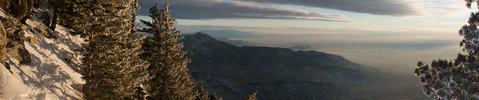
Earlier this evening however, I was able to stitch together a series of images into a panorama that only covers about half of the western view from my balcony.
I just finished making all of the annual changes that are involved in adding a new year to the diary and web site. When I changed the title page it struck me that starting the 14th year represents a significant chunk of time during which I have been keeping this journal of sorts.
On thing that is readily apparent is that during the last three years the actual writing of entries has suffered but the redemption is that there are many issues and events preserved in the photo blog. That really was kind of the plan, that the photo blog would serve as a placeholder until I had time to write, but somehow the time never seemed to appear.
I am also starting year four of my current job, at least from the travel count perspective. I started in August of 2008 and really didn’t start hitting the road until January of 2009. In the past three years I’ve averaged 100 flights a year and about 60 nights on the road.
Is it any wonder that just a couple of days ago I decided to bag another four day “trip” to San Francisco over the New Year? I told Mrs. that I’d had it with airplanes and that I was quite happy to stay in New Mexico for the weekend.
So we drove the seventy miles to Santa Fe and stayed there on Friday night, had great meals and experienced even more wonderful music over two evenings and were home by 9:00 on New Years Eve, long before the drunks hit the roads.
We even got in a trip to the hot springs at Ojo Calliente.
But that’s an entry for another day, photos and all.
Yesterday, on New Years day I took advantage of my season’s pass and rode the tram up to the top of the mountain for the second time in a week. I took out the snowshoes that were my Christmas present this year and headed on out to the trail. I was thinking that I might try and climb the whole mountain today but after a little over a hour of trail bashing, I decided that enough was enough and there was no reason for me to beat up my body for hours on end.
Although you can’t see it clearly in this image, there is a slight indication of a trail that is about 100 feet or so below the top of the ridge line, detailed below.
Unfortunately for me, the hiker who braved his or her way through the snow was not wearing snowshoes and basically stomped deep holes into the snow all the way across the lateral portion of this trail.
As you can see from this image, the slope is severe, and a fall could send you rolling downhill into some serious rocks or trees.
Had our errant wanderer used snowshoes I’m sure they would not have cursed the entire trip over from the saddle and they would have made it a lot easier for those who would follow behind.
I almost got to the first major turn to the west before I decided that I’d have enough and figured it would take a somewhere between one and two hours just to cover the one mile to the saddle, and then the same amount of time to return. When you consider that I can climb the entire mountain in about three hours in the summer, that kind of slog after a day of climbing is now off my agenda till the spring.
Looking to the north you can see the trail as it crosses from east to west. You can also see the incline that doesn’t really seem all that treacherous in the summer, but when it’s all leveled out with a blanket of snow and ice, everything changes.
Among the other things that I’ve done to keep myself busy from time to time is to build a portfolio of images that are inserted into Google Earth. So far just about every image that I’ve submitted has been accepted. Hopefully the larger image of this will be as well.
Like I said, I almost made it to the point where the trail makes it’s westerly curve, which would also be the point that is visible from the first image that I took a couple of days earlier.
Check out the larger image and perhaps you can imagine what it’s like to stomp through the snow at a little over 10,000 feet.
In the middle of last year I got this great new GPS from my daughter and son-in-law. Among other things it measures is your heart rate. I can tell you, and the print out is proof, it’s no walk in the park.
The devil, as they say, is in the details.
Anyone care to join me on my next slog? At least if you wear snowshoes, you don’t have to worry about punching “post holes” which is what happened to the poor person who made this trail.


